Showing posts with label new zealand. Show all posts

Haast's Eagle


After all the weird critters we have recently unearthed, this one is easy. An over sized eagle with easy to catch large land birds is a pretty creditable ecological niche. That it picked off the odd human child is no surprise.


That man likely hunted it to swift extinction is a certainty. The feathers alone would cause that. The bird also had no place to hide. It would be spotted going to its nest and be easily vulnerable.


This also suggests that such large birds might have existed once globally until mankind showed up and took an interest. Or perhaps this bird was unable to fly the distance to reach Australia and it is locally unique.


The one observation that we can make is that large predators require similarly sized prey that is readily available. This was true for Pleistocene mega lions and cave bears. Once the big ones were driven to the wall they followed.


Legend of giant man-eating New Zealand eagle is TRUE


By Daily Mail Reporter


Last updated at 5:45 PM on 15th September 2009


A massive man-eating bird of prey from ancient Maori legend really did exist, according to new research.


Scientists have known about the existence of Haast's eagle for over a century based on excavated bones, but the behaviour of these giant birds was not clear.


As the eagles weighed up to 40 lbs some scientists presumed they were scavengers rather than the predators from mythology.


But a new study has revealed the eagle as a fearsome predator that probably swooped on flightless birds and even children from a high mountain perch.


Researchers Paul Scofield of the Canterbury Museum in New Zealand and Ken Ashwell of the University of New South Wales used computerised CT and CAT scans to reconstruct the size of the brain, eyes, ears and spinal cord of this ancient eagle.


This data was compared to values from modern predatory and scavenging birds to determine the habits of the extinct eagle.


Professor Scofield said the findings are similar to what he found in Maori folk tales.


'The science supports Maori mythology of the legendary pouakai or hokioi, a huge bird that could swoop down on people in the mountains and was capable of killing a small child,' he said.


The researchers also determined the eagle quickly evolved from a much smaller ancestor, with the body growing much more quickly than the brain. They believe its body grew 10 times bigger during the early to middle Pleistocene period, 700,000 to 1.8 million years ago.


'This work is a great example of how rapidly evolving medical techniques and equipment can be used to solve ancient medical mysteries,' Professor Ashwell said.


They wrote their conclusions in the peer-reviewed Journal of Vertebrate Paleontology.


Scientists believe the Haast's eagle became extinct due to habitat destruction and the extinction of its prey species at the hands of early Polynesian settlers.


New Zealand paleontologist Trevor Worthy said: 'They provide a convincing case that the body of this eagle has rapidly enlarged, presumably adapting to the very much larger prey it had access to in New Zealand, but that the brain size had lagged behind this increase.'


Before the humans colonized New Zealand about 750 years ago, the largest inhabitants were birds like the Haast's eagle and the moa.


Super Volcano in Alps


I think that what is most remarkable about this story is how a stack of rock twenty five miles thick has been up lifted and tilted on its side presumably in order to reveal a surface mapping of the roots of a super volcano. That is a pretty neat trick.

It also gives us a scale of tectonic manipulation that was perhaps suggested in the past but not so nicely proven.
As mentioned, this bit of tectonic good luck will give us a pretty exact understanding, comparable to ordinary volcanoes, of the genesis of super volcanoes. Thus our modeling will have credence.

This luck should not be underestimated. We have one such in the North American Plate and that will eventually go extinct. I know of one other in Sumatra and that is it. They are simply not common at all. So getting one cut and laid out for inspection is a lousy bet.

I grabbed a list from Wikipedia and it adds a bit. We can include North Island in New Zealand. I also think that the other Idaho events on the list are all part of the Yellowstone event which is migrating eastward as is perhaps North Island. So we have three VE8’s known to science. I suspect that we must have another one in Alaska that is unrecognized. The rest are simply extinct if they are recognized at all.


Scientists find “Rosetta Stone” of supervolcanoes in Italian Alps

Ani
September 22nd, 2009

http://blog.taragana.com/n/scientists-find-rosetta-stone-of-supervolcanoes-in-italian-alps-174899/

WASHINGTON - A team of scientists has found the “Rosetta Stone” of supervolcanoes, in the form of a fossil supervolcano in the Italian Alps’ Sesia Valley.

A team led by James E. Quick, a geology professor at Southern Methodist University, US, found the fossil.

The discovery will advance scientific understanding of active supervolcanoes, like Yellowstone, which is the second-largest supervolcano in the world and which last erupted 630,000 years ago.

A rare uplift of the Earth’s crust in the Sesia Valley reveals for the first time the actual “plumbing” of a supervolcano from the surface to the source of the magma deep within the Earth, according to a new research article reporting the discovery.

The uplift reveals to an unprecedented depth of 25 kilometers the tracks and trails of the magma as it moved through the Earth’s crust.

Supervolcanoes, historically called calderas, are enormous craters tens of kilometers in diameter, which erupt hundreds to thousands of cubic kilometers of volcanic ash.

Their eruptions are sparked by the explosive release of gas from molten rock or “magma” as it pushes its way to the Earth’s surface.

Supervolcanoes have spread lava and ash vast distances and scientists believe they may have set off catastrophic global cooling events at different periods in the Earth’s past.

Sesia Valley’s unprecedented exposure of magmatic plumbing provides a model for interpreting geophysical profiles and magmatic processes beneath active calderas.

The exposure also serves as direct confirmation of the cause-and-effect link between molten rock moving through the Earth’s crust and explosive volcanism.

“It might lead to a better interpretation of monitoring data and improved prediction of eruptions,” said Quick, lead author of the research article reporting the discovery.

Calderas, which typically exhibit high levels of seismic and hydrothermal activity, often swell, suggesting movement of fluids beneath the surface.

“We want to better understand the tell-tale signs that a caldera is advancing to eruption so that we can improve warnings and avoid false alerts,” Quick said.

Quick likens the relevance of Sesia Valley to seeing bones and muscle inside the human body for the first time after previously envisioning human anatomy on the basis of a sonogram only.

“We think of the Sesia Valley find as the ‘Rosetta Stone’ for supervolcanoes because the depth to which rocks are exposed will help us to link the geologic and geophysical data,” Quick said. (ANI)


Known super eruptions (from Wikipedia)

VEI 8

VEI 8 eruptions have happened in the following locations.

Lake Taupo, North Island, New Zealand - Oruanui eruption ~26,500 years ago (~1,170 km³)
Lake Toba, Sumatra, Indonesia - ~75,000 years ago (~2,800 km³)
Whakamaru, North Island, New Zealand - Whakamaru Ignimbrite/Mount Curl Tephra ~254,000 years ago (1,200-2,000 km³)[6]
Yellowstone Caldera, Wyoming, United States - 640,000 years ago (1,000 km³)
Island Park Caldera, Idaho/Wyoming, United States - 2.1 million years ago(2,500 km³)
Kilgore Tuff, Idaho, United States - 4.5 million years ago (1,800 km³)
Blacktail Creek, Idaho, United States - 6.6 million years ago (1,500 km³)
La Garita Caldera, Colorado, United States - Source of the truly enormous eruption of the Fish Canyon Tuff ~27.8 million years ago (~5,000 km³)

The Lake Toba eruption plunged the Earth into a
volcanic winter, eradicating an estimated 60%[7][8][9][10][11] of the human population (although humans managed to survive, even in the vicinity of the volcano[12]), and was responsible for the formation of sulfuric acid in the atmosphere. However the coincidental agreement in above sources about percentage value of extinction is contrary to differing estimates of human population size at that time.

VEI-7 volcanic events, less colossal but still supermassive, have occurred in the geological past. The only ones in historic times are
Tambora, in 1815, Lake Taupo (Hatepe), around 180 AD,[13] and possibly Baekdu Mountain, around 979 AD.[14]

Tambora, West Nusa Tenggara, Indonesia - 1815 (160 km³)
Baekdu Mountain, China/North Korea - ~969 AD (96±19 km³)
Lake Taupo, North Island, New Zealand - Hatepe eruption ~181 C.E. (120 km³)[13]
Kikai Caldera, Ryukyu Islands, Japan - ~6,300 years ago (~ 4,300 BC) (150 km³)
Campi Flegrei, Naples, Italy - 39280 years ago (500 km³)
Laacher See, Rhineland-Palatinate, Germany - ~12,900 years ago (~300 km³)
Aira Caldera, Kyūshū, Japan - ~22,000 years ago (~110 km³)
Reporoa caldera, New Zealand - 230,000 years ago (~100 km³)
Aso, Kyūshū, Japan - four large explosive eruptions between 300,000 to 80,000 years ago (last one > 600 km³)
Long Valley Caldera, California, United States - ~760,000 years ago (600 km³)
Valles Caldera, New Mexico, United States - ~1.12 million years ago (~600 km³)
Mangakino, North Island, New Zealand - three eruptions from 0.97 to 1.23 million years ago (each > 300 km³)[15]
Henry's Fork Caldera, Idaho, United States - 1.3 million years ago (280 km³)
Walcott Tuff, Idaho, United States - 6.4 million years ago (750 km³)
Bennett Lake Volcanic Complex, British Columbia/Yukon, Canada - ~50 million years ago (850 km³)
Bruneau-Jarbidge, Idaho, United States - ~10-12 million years ago (>250 km³) (responsible for the Ashfall Fossil Beds ~1,600 km to the east[16])

Water and Subduction


This article is a fresh interpretation of a subducting slab of sea bottom and the impact of water release in three different zones of transition. I find it remarkable that it was possible to image the behavior using electromagnetic waves. This strongly suggests that we might eventually have a detailed mapping of the subsurface or at least a mapping of the zones of water alteration.

The ability to presently model the active edges of the Ring of Fire leads to complacency regarding everything else. This is still a young science that was woefully astray before plate tectonics.

The ring of fire it self surrounds slightly less than half the globe. Quite possibly the opening of the Atlantic produced crustal failure more or less on a North South equator and as the spreading opened up the Atlantic, the equatorial ring has been shrinking. Thus the perimeter formed by the Ring of Fire has absorbed an area equal to that created in the Atlantic. Assuming that it has not been significantly absorbed elsewhere it follows that we can write an equation of curvature compression for the ring with an known value on one side of the equation.

Thus we can develop our knowledge of Ring of Fire tectonics in quite small subsections and reasonably go looking for missing mass and the like.

I do not know if anyone has tried to do this yet but it would be neat to take it in thousand mile by thousand mile chunks to see where it all leads.

Shaking The Earth: Just Add Water

http://www.terradaily.com/reports/Shaking_The_Earth_Just_Add_Water_999.html

http://www.terradaily.com/images/tectonic-plates-australia-pacific-bg.jpg


This illustration shows a cross section of the Earth beneath New Zealand's South Island. This is one of the planet's youngest subduction zones, where the Pacific Plate collides with the Australian Plate and "subducts" or dives beneath it. The illustration, based on actual data from a University of Utah study, shows five places where water (lime green, yellow and reddish colors) is rising from the subduction zone to help pave the way for earthquakes, either by triggering quakes on steep thrust faults (far left), accommodating the motion of strike-slip faults like the Alpine fault and other faults (center and right) or by creating new faults or widening them (far right). Credit: Philip Wannamaker and Doug Jensen, University of Utah.


by Staff Writers
Salt Lake City UT (SPX) Aug 13, 2009

New Zealand is the site of one of the world's youngest subduction zones, where the Pacific Plate of Earth's crust dives beneath the Australian Plate. Now, a University of Utah study shows how water deep underground helps the subduction zone mature and paves the way for it to generate powerful earthquakes.


The study in the journal Nature "expands our understanding of the sources of earthquake failure," says Phil Wannamaker, the study's main author and a geophysicist at the University of Utah's Energy and Geoscience Institute.


"It hasn't been on people's minds that fluid-generating processes way out of sight reach up and cause damage right under our feet," he adds.


Understanding how one of Earth's moving tectonic plates can dive or subduct beneath another to create earthquake-generating faults is important because subduction and faulting "are major processes all over the world," especially in the "Ring of Fire" around the Pacific Ocean, Wannamaker says.


Wannamaker conducted the study with University of Utah geophysics student Virginie Maris; geophysicists George Jiracek of San Diego State University and Yasuo Ogawa of the Tokyo Institute of Technology; and five coauthors from New Zealand's government geology institute, GNS Science: geophysicists T. Grant Caldwell, Hugh Bibby and Wiebke Heise; student Graham Hill; and field technician Stewart Bennie.


Wannamaker says the study was financed by a $395,000 grant from the National Science Foundation. With additional funding from Japan and from the New Zealand Foundation for Research, Wannamaker estimates the total study cost at $600,000.


Subducting the Kiwis


New Zealand includes two major islands - the North Island and less populated South Island - that extend roughly northeast to southwest in the Pacific Ocean southeast of Australia. Like other nations along the Pacific "Ring of Fire" - including the western coast of North America - New Zealand sits atop a boundary between two of Earth's slowly moving tectonic plates, and thus has earthquakes and volcanism.


The plates, which can be 100 miles thick, include Earth's crust and the upper part of the mantle, the rock layer beneath the crust. New tectonic plates are born as volcanic eruptions at mid-ocean ridges add new rock to the plates on both sides of the ridges, like twin conveyor belts moving away from a ridge.


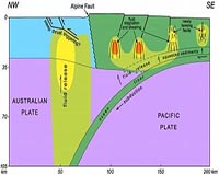
At the other end of these conveyor belts, where an oceanic plate collides with a continental plate, the seafloor plate subducts - or dives downward at a roughly 45-degree angle - beneath the continental plate, a process that generates earthquakes and volcanism.


New Zealand's subduction zone - the Hikurangi subduction zone - is considered young because only during the past 20 million years did the edge of the Pacific Plate collide with the Australian Plate in New Zealand and begin diving beneath it.


The zone includes two kinds of quake-generating motions because the Pacific Plate is colliding with the Australian Plate at New Zealand at an angle instead of head-on. Thus, the Pacific Plate not only is moving northwest and diving under the Australian Plate, but it also is sliding southwest under the Australian Plate at the same time.


So while the colliding plates create quake forces like those seen in other subduction zones such as the U.S. Pacific Northwest, the oblique movement also generates "strike-slip" pressures like those that created California’s San Andreas fault.


The oblique pressure has created four major strike-slip faults extending northeast to southwest along the length of the northern part of the South Island. Major earthquakes to nearly magnitude 8 have occurred along these and related faults over the past 200 years.


Picturing Water within the Earth


Rocks exposed from old, defunct subduction zones as well as current "Ring of Fire" volcanic rocks show water is released during subduction, so the researchers wanted to determine the role of this water in the maturation of the young subduction zone.


They used a method called magnetotelluric sounding, which is similar to using X-rays for CAT scans of patients and seismic waves to search for oil and gas.


Magnetotelluric sounding uses natural electromagnetic waves generated by the sun and by lightning bolts. Most such waves travel through the air, but "a portion penetrate the Earth, scatter off rock structures of interest and return to the surface, where we can measure them" using fancy volt meters, Wannamaker says.


As the electromagnetic waves pass through Earth's interior, they travel faster or slower depending on the extent to which rock and other material conducts or resists electricity. Water is more conductive, so it can be detected by this technique.


During 2006 and 2007, Wannamaker and colleagues made measurements at 67 sites along a 125-mile line crossing the northern end of New Zealand's South Island.


Patterns of backscattered electromagnetic radiation from all the stations then were assembled by a computer program to create an image of Earth's crust and upper mantle along a cross section of New Zealand's South Island.


The image revealed large amounts of water in different areas and at different depths, which in turn suggested three distinct processes by which the fluid deforms the crust above it and helps pave the way for earthquakes:


Beneath the South Island's eastern coast, where the Pacific Plate begins to dive under the Australian Plate, water is released about 10 miles underground. It comes from seafloor sediments that are squeezed as they are carried underground on the subducting Pacific Plate. Much of the water rises upward into the overlying crust of the Australian Plate, cracking the crustal rock further to create and widen existing cracks.


This "mesh" of fault fractures "is weakening the crust and promoting the formation of new strike-slip faulting," Wannamaker says.


Farther west, water is released from hydrated rock - rock with chemically bound water - within the subducting Pacific Plate. The water collects within cracks roughly 6 to 20 miles underground in the "ductile" or taffy-like part of the Earth's crust.


Such fluids help accommodate the oblique or southwesterly motion of the Pacific Plate under New Zealand - motion that created the strike-slip faults on the South Island.


"These fluids certainly could burst upward into the strike-slip zone and trigger major earthquakes," Wannamaker says. "And many smaller quakes have been centered along the edges of these reservoirs."


The largest accumulation of water beneath the subduction zone also is the deepest and farthest west beneath the South Island. Freed by the action of heat and pressure on hydrated minerals, the water forms a huge plume extending upward from depths of 60 miles or more - something also seen in older, more mature subduction zones.


It appears these fluids trigger major earthquakes - and did so during magnitude-7 and larger earthquakes in the Murchison area in the early 20th century, Wannamaker says.


Faults in that area are high-angle thrusts, meaning that during quakes, ground on one side of the fault moves up and over the ground on the other side.


Laws of rock mechanics say such faults should not rupture when they are steep, because it is difficult to push one block of ground up and over the other when the fault between them dips at an angle of more than 30 degrees - unless water is present. Yet big quakes near Murchison have occurred on faults that dip at angles of more than 55 degrees, Wannamaker says.


That suggests subduction zone water makes quakes possible on such steep faults. "The fluid pressure is rising through the upper mantle and deep crust and into the upper crust, and props open the high-angle thrusts, allowing them fail," Wannamaker says.


In older subduction zones - including the zone off New Zealand's North Island - the water from great depths moves largely straight upward into the hot upper mantle, lowering the melting temperature of the rock and ultimately leading to the formation volcanoes on the land above. Subduction has not yet injected the upper mantle with enough water to trigger volcanism on the South Island, Wannamaker says.

Giant Cod and Whales

This is the first serious measure of what has been lost in terms of our global fishery. Of much more concern is the ongoing lack of willingness to tackle the economic fallout and to establish protocols that can bring about recovery.

The loss is huge and catastrophic. Recovery must take decades and in some instances it will take centuries. That is necessary is obvious to everyone, and delay is beginning to wear very thin. This is a valid cause for Greenpeace to take on and develop.

Right now, we are passing through the era of the last common fisheries in which the stakeholders are been squeezed out of their livelihoods. Since no one is prepared to step up and manage anything except political spin, it is reasonable that the Alaska fishery will be soon destroyed. It is also obvious that even the mid ocean fisheries are been diminished by practices that can be described as boneheaded stupid.

Two things have to happen once all fisheries are driven to economic failure.

Fishery title must be established by international convention on the basis of a guaranteed annual tax remittance and bonded accordingly.

A system of refuges must be established and rigorously enforced. Fish are not overtly territorial but are predictable enough that coastal strips and certain reefs and the like act as nurseries for the production of both juveniles and mature fish. Checkerboard refuges can be established for bottom dwellers, allowing the surplus to constantly repopulate fishing areas. Everyone uses gps today, so it has become completely practical.

Thus if you want to fish, you will bid the fishery for twenty years or so at a crack with renewal rights and provide a guaranteed minimum every year. This forces one to maintain the health of the fishery. It is chancy and difficult, but also rewarding to the good operator.

Even fishing in pre determined quarter mile strips that are spaced a half a mile apart and are miles long should work very well. It would leave the sea full of fish and create natural refuges for most species. It could also put the catch on an upward trend.

I am sure that this will be argued as naïve but the technology exists to provide the necessary compliance framework.


Giant cod and whales were once plentiful: researchers

by Staff WritersWashington (AFP) May 26, 2009


http://www.terradaily.com/reports/Giant_cod_and_whales_were_once_plentiful_researchers_999.html

Just 200 years ago, tens of thousands of whales swam the waters around New Zealand while sharks patrolled the British coastlines, say researchers who tell of lost abundance in the world's oceans.

Around 100 global experts have united under a group called the Census of Marine Life to study the state of the Earth's waters from a historical viewpoint and how advances in technology have wielded devastation on sealife.

The decade-long project brings researchers to Vancouver, Canada from Tuesday and aims to publish its final report in 2010 with inputs from historical accounts as well as geological, botanical and archeological research.

"What we are looking at is a global picture of decline because of fisheries and habitat destruction," said Poul Holm, professor at Trinity college Dublin and one of the authors of a report to be presented at the three-day conference.

The revolution in fishing first came in the 1600s, when boaters began taking their vessels out in pairs to fish with nets. Then, large scale fisheries began to take hold in the 1800s.

"The impact of early fisheries was substantial," Holm told AFP. "The impact on ocean life has been enormous. And it happened earlier than anyone would have thought."

Not so long ago, marine fauna was more abundant, fish were bigger and predators more numerous.

But the size of fish began to decline in Europe from the Middle Ages with the first mass-scale fisheries, and the variety of underwater sealife began to shrink as well.

Today, even the predator population is but 10 to 15 percent of what it was at the start of the 19th century, researchers say.

One hundred years ago, cod measuring 1.5 meters (nearly five feet) was frequently sold while today the biggest are around 50 centimeters (20 inches) because of overfishing and the trend of catching the cod too early.

The cod's average lifespan has also dropped dramatically from 10 years to barely 2.8, according to Holm.
Researchers point to losses in the whale population particularly around New Zealand, whose waters boasted between 22,000 and 32,000 whales at the start of the 1800s but only had about 25 in 1925. Around a thousand live today off the country's southern coast.

In the same area, where historians say settlers began moving to in the 13th century, the snapper population was seven times higher then.

In most of the zones studied, changes brought on by human activity stretched on for a periods of more than a thousand years but radical changes are also observable within the space of just a few dozen years.

In south Florida's Key West for example, the average size of a fish in the mid 1950s was 20 kilograms (50 pounds). Today it is 2.3 kilograms (five pounds).

Still Holm says the findings give reason for hope.

"It's very useful to just be aware of what we have lost," said Holm.

"Although we are detecting a story of decline, its actually a hopeful message," he added.

"Because we can use the evidence to suggest that if we step back, if we introduce
conservation measures, fisheries regulations and avoid some of the stresses that cause harm to ocean life, we will be able to rebuild ocean life to a level which provides a lot of hope and would be able to feed many more people than the oceans are able today."

North and South were out of Synch during Holocene

This is an interesting bit of data. Some very good work has established that the climate separation between hemispheres is much more decisive than we had any reason to either conjecture or support. That there is a present separation in climatic behavior is apparent but there was no reason to think of such a separation as other than temporary.

Now we can expect such separation as normal and this goes a long way to downgrading the likely importance of solar output variation as a climate driver, unless as a driver, it obviously changes wind systems that give us such a signature. Except been out of synch, that is also militated against.

This is actually the first positive evidence that works directly against the solar proposition should it stand up. The time frames are too variable and large to accept any attempt to fine tunes results.

My own instincts have always been to view the sun a flat out fuel maximized burning system that simply is unable to vary in any significant manner. That we have fussed over the little surface variation observed is useful in piecing together solar dynamics and developing a model for magnetic field variation.

The fact is that our own internal variation in managing our own climate is superior to any solar variation and this powerfully dominant system needs to be respected more because it stores heat for later release much better than obvious.
This is an important finding and needs to be additionally confirmed.

North and south were out of synch

The Mediaeval Warming Period and Little Ice Age features of past climate in the Northern Hemisphere are backed up by extensive evidence but there is much less data on palaeoclimate available for the Southern Hemisphere. As a result it hasn't been clear whether these phenomena extended across the globe.

Now a team from the US, France, New Zealand, Norway and Switzerland has come up with a technique for precisely measuring the date at which glaciers in New Zealand's Southern Alps began to retreat. Their study indicates that climate in the southern hemisphere was frequently out of step with climate further north over the last 7,000 years or so, during the Holocene period.

"The robust finding of our work is that the glaciers in New Zealand were out of phase with those in the northern hemisphere – Swiss Alps and Scandinavia," Joerg Schaefer of the Lamont-Doherty Earth Observatory told environmentalresearchweb. "This holds true in particular for the prominent northern climate feature labelled the Medieval Warm Period-Little Ice Age interval, the former being a warm period between about 900–1100 AD and the latter being the dominant cold in the north during the Holocene. This result argues for the importance of regional climate drivers, and we suggest changes in atmospheric circulation patterns to be important."

Schaefer and colleagues used a cosmogenic dating technique to analyse glacier fluctuations. By measuring the concentration of beryllium-10 in the moraines deposited by the glaciers they were able to date the glacier's retreat. Beryllium-10 forms when cosmic rays hit rock and concentrations gradually build up over time.

"New Zealand has one of the best resolved and preserved moraine records worldwide, and our team refined the cosmogenic dating method to a degree that we now can date even the young Holocene moraines," said Schaefer. "Holocene climate signals are small in amplitude, [and] very hard to detect in any climate archive. Glaciers are extremely sensitive to such small changes, and even the small climate swings of the Holocene forced the glaciers to fluctuate signficantly, which is documented in the moraine record – sediment ridges the glacier piles up while the glacier is steady in one position, i.e. in equilibrium with the prevailing climate."

The researchers found that New Zealand's Mueller, Hooker and Tasman valley glaciers have fluctuated frequently over the last 7000 years, with glacial advances becoming slightly smaller over time. Glaciers around Mount Cook reached their largest extent around 6,500 years ago when the Swiss Alps and Scandinavia were relatively warm. Northern glaciers, on the other hand, hit their peak roughly 6000 years later, during the Little Ice Age of 1300–1860 AD. New Zealand glaciers showed additional peaks during the northern hemisphere's Mediaeval Warming Period, just before the Little Ice Age.

"Our results also manifest how frequently the southern glaciers fluctuated during the rather stable Holocene," said Schaefer. "This illustration of the outstanding sensitivity of glaciers to small climate changes is a worrying finding giving the ongoing climate warming."

The researchers reckon atmospheric circulation changes in the southwest Pacific were a factor in forcing the glacier fluctuations.

Now the team would like to use its dating technique to create a global map of glacier fluctuations that would "provide information about climate changes on the continents we do not have yet, and would, in turn, provide a rigorous calibration data set for any climate models".

"This is what we have in mind for the near future in an effort that certainly includes the wider community due to its very ambitious scope," said Schaefer. "But I am very optimistic that we can get this done."
The researchers reported their work in Science.

About the author
Liz Kalaugher is editor of environmentalresearchweb.